

Bathymetry
 During this project we added new interfaces that allow the AquaModel simulation to incorporate output from detailed bathymetry. The detailed bathymetry combined with 3-dimensional ocean current data allows the AquaModel to accurately track the movement of uneaten feed and fish feces as it sinks through the water column so that AquaModel can determine whether such waste is deposited near the mariculture site or transported away from the site by water column or bottom currents. Accurate tracking of waste is the most important factor in determining the environmental impact of open ocean fish farms.
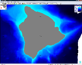
The new version of AquaModel utilizes detailed bathymetry here to define the depth of the water column at each grid cell location. Prior versions were restricted to a uniform grid where the ocean bottom was modeled as flat and level. Waste products transported by ocean currents may travel further from a farm site if the bottom depth is deeper. Modeling of an uneven bottom depth therefore provides for a more accurate assessment of the distribution of farm waste products.